
V9 GNSS RTK SYSTEM 1.Seamlessly Compatible CORS System 2.Soundable Intelligent RTK GPS System 3.attractive price
V9 GNSS RTK SYSTEM
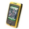
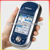
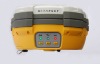
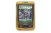
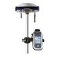
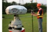
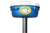
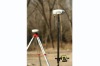
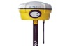
Noble Origin, Unsurpassed DesignThe Hi-Target V9 CORS RTK is a latest advanced multi-channel, multi-frequency GPS system based on the CORS technology, adopting ultra-long-distance RTK technology, can receive the coming L5 signal of the third generation GPS and GLONASS signal.V9 CORS RTK employs the Sound Navigation technology to instruct the whole process of operation. Combined USB device file management technology, files towed download; Integrated built-in main unit, waterproof, dustproof, shock-resistance design, detailed considerations for field work environment; mature GPRS/CDMA network communication technology, one-key switch between GPRS/CDMA/UHFBased on regular RTK applications, completely seamless compatibility with CORS. Economical HD-CORS technology for initiative of network-building. V9 GNSS RTK system with its noble origin and unsurpassed design, is the ideal assistant to your surveying job.8 Technology BreakthroughsSeamlessly Compatible CORS SystemDesign for the technology of CORS system, perfect network data transmitting, seamless join with CORS system, one single receiver can perform RTK work. V9 is the ideal choice as the rover survey terminal for CORS system.Initiative of Network-Building HD-CORS TechnologyThe HD-CORS (Continuous Operation Reference Station) which comprises Hi-Target unique data transmitting network server technology, excellent long-distance RTK working technology, and V9 CORS RTK system, has many advantages including free network-building, low run cost, convenient maintenance, suitable for surveying requirement of regional continuous RTK work in medium & small city.GPRS/CDMA/UHF/URS Data Transmitting TechnologyMature data net communication (GPRS/CDMA) technology is compatible with data transmitting by UHF / URS. With powerful anti-disturbance, GPRS data transmitting technology gets rid of the limit of working distance, especially suits to work at low cost in tough area, such as in urban, mountain area where the traditional radio signal is seriously blocked.Soundable Intelligent RTK GPS SystemWith the initial innovation of Soundable Intelligent Technology, the V9 RTK receiver is able to speak to prompt the operation you have just performed and to inform the current working condition.USB Device Files Management File management adopts USB device storage technology, plug and play, towed download, without the trouble of program download.Superb long-distance working technology Powered by the latest advanced NovAtel OEMV dual-frequency motherboard, V9 RTK receiver gets rid of the limit of traditional RTK working distance, and make your GPS system perform higher benefits by using the long-distance working technology.Supports GNSS Modernization Powered by the Latest Advanced NovAtel dual-frequency motherboard, Hi-Target V9 RTK receiver can get GLNASS signals and support the coming L5 band and the new L2 C/A signalsby software upgrading technology.Completely Enhanced Integration System DesignIntegrated RTK receiver with industry-standard design, enhances main unit design with waterproof rubber loop and mat in the hostile working environmentof the field. Waterproof, dustproof and shock-resistent.Rover ReceiverIndustry-level Integrated MainframeIndustry-level design with waterproof rubber loop and mat, waterproof, dustproof and shock-resistent.Completely integrated built-in industry-level receiver unit, solid and compact.Built-in reliable wireless bluetooth device, eliminate the traditional limit of cable.Card Slot & Built-In Dual Lithium BatteryEmbedded GPRS/CDMA communication module, easy-operated.Built-in dual lithium battery, ensure switching power without interrupting your surveying work,large battery capacity for12 hours continuous workIndustry-Level ControllerDolphin 9500 industry-level touched-colorful-screen controller, built-in blue-tooth wireless communication with GPSreceiver.Operation in English version by professional RTK controller software,allows you to experience easy job in the field.Controller Bracket & Carbon-Fiber PoleProfessional controller bracket support fixing angle at any direction, convenient for rotation, equipped withprofessional compass to improve efficiency.2M carbon fiber GPS pole, portable and durable with precise level bubble, allows you to control your operationeasilyControl PanelUnique control panel design with 2 keys and 3 LED indicators, plus intelligent voice navigation.USBCommunicationPort64M large capacity of FLASH memory meets the need of 120 hours continuous static data collection.USB communication port, plug and play; USB device static data download make you experience the joy of highspeed downloadBase Station FeaturesIndustry-Level Integrated DesignBlue-tooth highly integration, waterproof, dust-proof and shock-resistent,floatable, bear 2 meters natural dropIntelligent Base Station Technologysupport one-key set at any point, rover receiver opposite direction setting, and view the base station battery power remaining from long distanceProfessional UHF Data Link Technology460M/230M data transmitter, maximum 19200bps transmitting speed, less power loss and more stableMature GPRS/CDMA Technology Completely built-in GPRS modulewithout big battery, no communication obstacle, without distance limit, especially suitable for surveying in hostile areas( urban, mountain area ect.)control base station and send message to each other.Support UHF/GPRS Broadcast SimultaneouslyUHF and GPRS data link can be set broadcasting simultaneously, one key switching between UHF and GPRS data link on the rover receiver, dual insurance for the data communication.Professional Network Server Technology24 hours network server online support, performing real time monitor, data save and online upgrade,ect.Industry-Level Integrated MainframeIndustry-level design with waterproof glue rubber and mat, waterproof, dustproof and shock-resistent. Integrated complete built-in industry-level receiver unit, solid and compact.Built-in reliable wireless blue-tooth device, eliminate the traditional limit of cable.Control PanelUnique control panel design with 2 keys and 3 LED indicators, plus intelligent voice navigation.Card Slot & Built-In Dual Lithium BatteryEmbedded GPRS/CDMA communication module, easy-operated.Built-in dual lithium battery, ensure switching power without interrupting your surveying work, Large batterycapacity for 12 hours continuous workCarrying CaseSolid & durable, light weight, portable & striking color fit field workUSBCommumentionPort64M large capacity of FLASH memory meets the need of 120 hours continuous static data collecting.USB communication port, plug and play; USB device static data download make you experience the joy of high speed downloadExternal Communication ModuleAvailable for UHF radio or URS data transfer station16 channels can be used on UHF radio, High or Low frequency alternative100 channels can be used on URS data transfer station, maximum transmission distance is 50kmTechnique Parameter1, Receiver Component2,Internal UHF Radio Component3,GSM Module4,Port Component5,Panel Key-Press and Lamp6,Positioning Specifications/Accurancy
……
please refer to our website for details
V9 GNSS RTK SYSTEM