
MobileMapper 6 handheld GPS 1.attractive price 2.Quality assurance 3.Versatile Mobile GIS Solution
MobileMapper 6 handheld GPS
MobileMapper 6
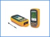
True Mobile GIS for EveryoneMobileMapper 6 provides a complete set of all necessary features required by a mapping device for anyone who needs productive data collection and efficient asset management in the field. Unlike consumer-grade units, the low-cost easy-to-use MobileMapper 6 offeers full compatibility with popular GIS software to enable companies to select and use GIS software of choice.Performance GPSMobileMapper 6 GPS engine provides professional accuracy in real time and post-processing. This SBAS-enabled high-sensitivity GPS receiver computes and updates your position even in difficult conditions, such as under tree canopy and in urban surroundings.Versatile Mobile GIS SolutionThe MobileMapper 6 comes with Microsoft Windows Mobile 6 operating system, a color touch-screen, and it has Bluetooth for wireless connectivity. You can collect GIS/GPS points and maps via the GIS application of your choice: either a third party software or the proprietary Ashtech MobileMapper Field software. You can also navigate, get your direction from the integrated e-compass, and communicate wirelessly.Field-proven Rugged DesignMobileMapper 6 fits comfortably in one hand and weighs less than eight ounces (224g). It is made for intensive outdoor use and can be dropped in the dirt or into water again and again without harm. It keeps working, and you won't lose any data.Feature-rich Mapping DeviceEmbedded speaker and microphone make it easy to record audio files, for a rich archive of locations and projects. You can take pictures using the integrated 2-megapixel digital camera, use the e-compass to determine the camera orientation at the time the picture is taken, and use other Windows Office Mobile applications, all with a single device.Software OptionsMobileMapper Field software: Ashtech software provides easy-to-use and simple yet professional and effective GIS data collection capabilities. You can select this optional Mobile Mapping application to create and update maps for analysis and maintenance in a standard GIS system. MobileMapper Office: Use this software option to differentially post-process raw GPS data collected with the Ashtech MobileMapper Field software. Through post-processing, the positions of every GIS feature you collect in the field can be improved to sub meter (< 1m) accuracy.ESRI ArcPad (USA only): Mobile GIS and field mapping software for ArcGis users. (Bundle offer)GPSDifferential for ArcPad 8: post-processing software extension for ArcPad 8. (Bundle offer)
MobileMapper 6 handheld GPS